


Original price was: £209.99.£96.99Current price is: £96.99.
- The Quality Choice for Smart Shoppers
- Safe Payments, Happy Customers
- Made of environmentally friendly materials
- Hassle-Free Payments

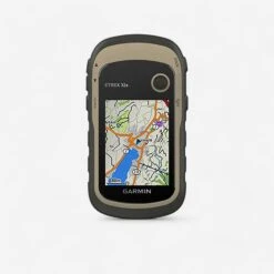
Designed for easily finding your bearings and measuring gradient on trails, long-distance walks and roads during your outings (maps included).A hiking GPS with functions that are essential (gradient, electronic compass) and an accessory to fit the GPS on your backpack strap.
LOOK WHERE YOU’RE GOING
The eTrex 32x comes with an optimised 2.2 inch screen, 65,000 colours and antireflective technology. Hard-wearing and waterproof, the eTrex 32x is designed to resist the elements. The casing protects its characteristic solidity, resistant to dust, dirt, dampness and water.
EASY TO FIT
Attach your hiking GPS eTrex 32x to your backpack using the accessory supplied in this Pack (DECATHLON exclusive). It enables you to grab your GPS quickly and fit it back on your backpack strap and has a small cord to avoid accidental drops.
ENJOY WORLDWIDE MAPS
The eTrex model can receive GPS and GLONASS satellites simultaneously. It has the capacity to use 24 more satellites than with GPS alone. The time required to locate its position is 20% quicker than with a simple GPS.
Equipped with a high-sensitivity, EGNOS compatible receiver, and with the HotFix satellite forecasting system, the ETrex quickly and accurately calculates your position. It maintains its GPS position even in densely wooded areas and deep valleys
GARMIN TOPOACTIVE EUROPE MAP
47 countries: Albania, Germany, Andorra, Austria, Belarus, Belgium, Bosnia-Herzegovina, Bulgaria, Croatia, Cyprus, Denmark, Spain, Estonia, Finland, France, Greece, Hungary, Ireland, Iceland, Italy, Kosovo, Latvia, Liechtenstein, Lithuania, Luxemburg, Macedonia, Malta, Moldavia, Monaco, Montenegro, Norway, Netherlands, Poland, Portugal, Czech Republic, Romania, United Kingdom, Russia (Kaliningrad), San-Marino, Serbia, Slovakia, Slovenia, Sweden, Switzerland, Turkey, Ukraine, Vatican.
EXPERIENCE UNFORGETTABLE MOMENTS!
The eTrex 32x has the latest GPX files to take you on treasure hunts and countless adventures in search of hidden gems. Come and visit the Geocaching.com site to download treasure hunts on your device and then it’s all up to you! The etrex 32x retains all essential information, particularly location, terrain and difficulty levels, tips and descriptions.
PLAN YOUR NEXT TRIP
Take control of your next adventure with BaseCamp™. This free route planning software allows you to visualise and organise your maps, routes and so much more. You can even create Garmin Adventures to share with friends, family and other explorers. BaseCamp provides topographic map data in 2D or 3D on your computer screen and also has a huge range of satellite images as it is teamed with BirdsEye
PHYSICAL FEATURES AND PERFORMANCE
Sizes: 5.4 x 10.3 x 3.3 cm
Display format (width by height): 3.5 x 4.4 cm; 5.6 cm diagonal
Screen definition (width by height): 240 x 320 pixels
Display type: Transflective TFT colour screen, 2.2 inches, 65,000 colours
Weight: 141.7 g with batteries
Battery: 2 AA batteries (not provided); NiMH or Lithium recommended
Battery life: Up to 25 hours
High-sensitivity receiver: YES
PC interface: USB
Barometric altimeter: YES
Electronic compass: YES
CARDS AND MEMORY
– Base map: YES
– Preloaded maps: Garmin TopoActive Europe
– Option to add maps: YES
– Built-in memory: 3.7 Go, preloaded maps included
– Memory cards accepted: microSD™ map (not supplied)
– Personalised places of interest (option to add favourite places of interest): YES
– Waypoints: 2000
– Routes: 200
– Track log: 10,000 points; 200 saved routes.
OUTDOOR ACTIVITY FEATURE
– Automatic route planner (step-by-step itinerary): Yes (with optional mapping for detailed routes)
– Geocache Mode: Yes (paperless)
– Compatible Custom maps: YES
– Sunrise/sunset information: YES
– Tide schedule: Yes (with BlueChart optional)
– Calculation area: YES
– JPEG viewer: YES
CONTENTS OF THE PACK
– Hiking GPS ETrex 32x
– Backpack accessory
– USB Cable
– Documentation
(batteries not supplied)
WEIGHT
142 g
Be the first to review “Garmin 32x Hiking GPS – Beige”
Related products


Hiking Gear and Equipment
Hiking Gear and Equipment
Hiking Gear and Equipment

Hiking Gear and Equipment
Traffic-free Cycle Trails: The Essential Guide To Over 400 Traffic Free Trails

Hiking Gear and Equipment

Hiking Gear and Equipment

Hiking Gear and Equipment


Hiking Gear and Equipment
Reviews
There are no reviews yet.